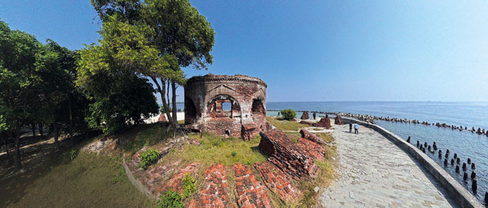
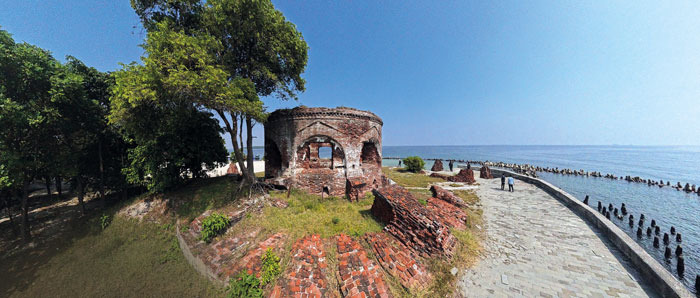
마텔로 요새는 수세기 동안 자랑스럽게 서 있으며 켈로르섬에 도착하는 방문객을 따뜻하게 맞이합니다. 사진: 데스 시아프리잘
백사장, 산호초, 고요한 해변 리조트를 넘어 케푸라우안 세리부 (천 개의 섬)은 유산과 역사에 깊이 스며든 매력적인 섬 순환 경험을 제공합니다. 17세기 초부터 네덜란드 동인도 회사(VOC) 그리고 나중에는 네덜란드 식민 정부를 위해 완충 구역 및 방어 기지로 사용되었습니다. 오늘날 이러한 역사 유적은 전국에 산재해 있으며, 방문객들에게 인도네시아의 해양 과거와 자카르타 해안 섬의 아름다움을 제공합니다.
천 개의 섬 군은 자카르타 만의 수역에 위치하며 서쪽에는 탄중 파시르, 동쪽에는 탄중 카라왕이라는 두 개의 해안선으로 둘러싸여 있습니다. 제도 남단에는 라묵, 운퉁 자와, 온루스트, 켈로르, 치피르, 비다다리 등 10개의 작은 섬이 있습니다. VOC 시대부터 네덜란드 식민지 시대까지 이들은 바타비아(자카르타)를 보호하는 데 전략적인 역할을 수행했으며 방어 요새, 검역 시설, 창고, 운송 허브로 사용되었습니다.
오늘날 많은 섬이 관광지로 변모했습니다. 아예르와 비다다리는 인기 있는 리조트 휴양지가 되어 있지만, 운퉁 자와는 남쪽 그룹에서 유일하게 영구 거주하는 섬으로 남아 있습니다.
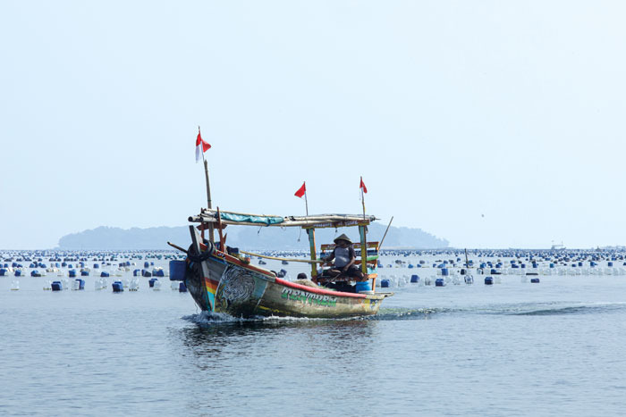
어부가 자카르타 만을 건너며 역사적인 섬들을 지나갑니다. 사진: 데스 시아프리잘
NOW! 자카르타는 다음 해 자카르타 500주년을 맞이하여 천 개의 섬을 방문했습니다. 행사는 도시의 해양 유산을 보존하고 홍보하며 관련 프로그램을 만들어내는 데 중점을 두었습니다. 북 자카르타의 카말 무아라 제트티에서 출발하여 바다 박물관 관리 부서장 미스'아리와 함께 박물관 바하리 배를 타고 켈로르, 치피르, 온루스트 섬으로 향했습니다.
이러한 역사적인 섬들은 해양 박물관 관리 부서에서 관리하는 유산지 중 하나이며, 박물관 바하리, 메나라 시아반다르, 코타 인탄 다리, 루마 시 피퉁, 마룬다 역사 유적지와 함께 있습니다.
우리는 컬러풀한 배들이 해안가를 따라 늘어선 카말 무아라와 다답 어촌을 지나갔습니다. 20분 후에 우리는 첫 번째 목적지인 켈로르 섬에 도착했습니다.
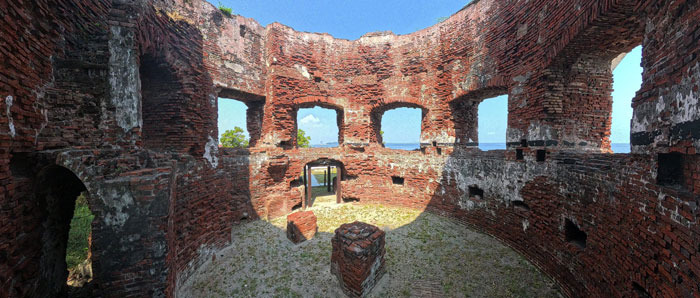
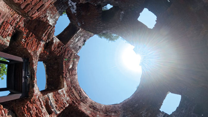
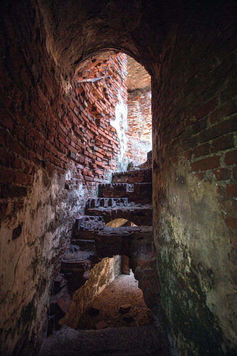
(위) 마르텔로 요새 내부에서, 방문객들은 시간이 흘러도 여전히 굳건하게 서 있는 역사적인 요새를 볼 수 있습니다. (아래 왼쪽) 해가 마르텔로 요새에 비추고 있으며 해발 약 9미터 높이에 위치합니다. (아래 오른쪽) 마르텔로 요새 내부의 계단은 지상층에서 지붕 플랫폼까지 연결하도록 설계된 나선형 벽돌 구조입니다. 군사 시절에는 지붕이 대포를 배치하여 주변 수역을 감시하고 보호하는 역할을 했습니다. 사진: 데스 사프리잘.
켈로르 섬은 비교적 작고, 수세기 동안의 해안 침식으로 인해 현재는 면적이 1.5헥타르에 불과합니다. 네덜란드 식민지 시대에는 "묘지 섬"이라는 의미의 Kerkhof Eiland로 알려져 있었습니다. 그러나 이름처럼 무덤이나 매장지의 증거는 발견된 적이 없습니다.
섬은 독특한 마르텔로 요새로 쉽게 구별됩니다. 역사가들이 코르시카, 프랑스 해안을 따라 건설된 원래 마르텔로 방어 시설에서 직접 영감을 받았는지 여전히 논쟁하고 있지만, 인도네시아 다른 곳에도 유사한 방어 구조물이 있습니다. 온러스트, 치피르, 비다다리 섬에도 유사한 탑이 건설되었으며, 모두 현재 바닷속으로 사라진 카랑 트리고손과 카랑 마틸다에서도 발견되었습니다. 이들은 19세기에 설립된 더 광범위한 해상 방어망의 일부였습니다.
1850년에 건설된 켈로르 섬의 요새는 주로 빨간 벽돌로 지어진 원형의 통 모양 구조물입니다. 직경 약 14미터이며 벽은 두께가 2.6m에 달합니다. 인상적인 외관에도 불구하고, 이 탑은 원래 방어 목적으로 20년 미만 사용되었습니다. 1871년에는 네덜란드 동인도 제국 함대의 탄약 창고로 개조되었습니다.
군사적 중요성이 점차 감소했고, 20세기 초반에는 대부분 사용되지 않았습니다. 1905년에 출판된 "Verlaten Eilanden" (버려진 섬)이라는 신문 기사에서 이 요새는 방치되고 훼손되었다고 묘사했습니다. 많은 손상은 1883년 크라카토아 화산의 파괴적인 분출로 인해 발생한 것으로 여겨집니다. 이 분출은 해안선 전체를 황폐하게 한 쓰나미와 충격파를 일으켰습니다.
북쪽에서 만에 들어오는 어떤 선박이든 켈로르를 처음 마주치게 되어 중요한 첫 번째 방어선 역할을 했습니다.
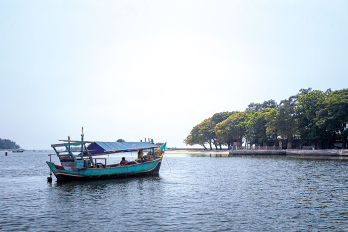
배가 접안대에 다가와 칩이르섬에 정박하려 합니다. 사진은 데스 사야프리잘이 찍었습니다.
우리는 켈로에서 칩이르섬으로 계속 이동했습니다. 이 섬은 카히양안섬(네덜란드어: Kuiper Eiland)이라고도 하며, 18세기와 19세기 지도에 유럽 정착지로 표시되었고 VOC의 운영에서 중요한 역할을 했습니다.
회사가 번성했던 시절에는 칩이르섬이 저장 및 물류센터 역할을 했습니다. 이 시기의 가장 생생한 기록 중 하나는 요하네스 라흐가 1769년에 그린 그림입니다. 이 그림은 VOC 상선 브리덴루스트가 수리를 받고 있는 모습을 보여줍니다. 노예들이 감독관이 채찍을 들고 지휘하는 아래에서 배를 세우는 모습은 식민지 무역 뒤에 숨겨진 인간의 비용을 생생하게 보여줍니다.
1850년부터 1853년까지 마르텔로 요새가 섬에 건설되었습니다. 그러나 군사적 역할은 단기간에 끝났고, 이후 건물은 창고로 개조되었습니다. 19세기 말에는 요새의 대부분이 철거되어 완전히 다른 목적으로 사용되는 시설을 위한 공간을 마련했습니다. 격리입니다.
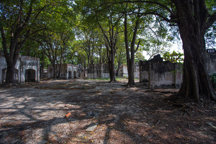
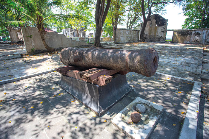
(왼쪽) 칩이르섬의 격리 시설 건물; (오른쪽) 대포가 칩이르섬에 있는 과거 병원과 격리 중심의 유적 사이에 서 있습니다. 사진은 데스 사야프리잘이 찍었습니다.
온러스트섬과 함께 칩이르섬은 중요한 공중 보건 기지가 되었습니다. 격리 시설 건축은 1911년에 시작되었고, 다음 해에는 운영되었습니다. 이 섬은 감염병에 걸린 여행자를 수용했으며 나중에 하jj 순례와 밀접한 관련이 생겼습니다.
본토의 의료 시설이 개선됨에 따라 이 섬의 중요성은 점차 감소했습니다. 1958년까지 격리 단지는 사용되지 않게 되어 결국 버려졌습니다. 과거 병원 건물 중 많은 부분이 철거되었고, 주민들은 인근 정착지에서 사용하기 위해 벽돌과 목재를 분해했습니다.
우리의 마지막 목적지는 자카르타 만에서 가장 바쁘고 중요한 섬이었던 온러스트섬입니다. 이 이름은 네덜란드어 onrust에서 유래했는데, "불안하다" 또는 "끊임없는 활동"을 의미하며 오랫동안 해상 무역과 해군 작전의 중심지 역할을 했습니다.
바타비아 북쪽에 전략적으로 위치한 온러스트섬은 VOC의 가장 중요한 섬 기지 중 하나가 되었습니다. 배, 물품, 근로자의 끊임없는 이동으로 아시아와 유럽을 여행하는 선박을 지원하는 번영하는 허브로 변했습니다.
그의 책 《Onrust dan Sekitarnya: Gugusan Pulau Bersejarah di Teluk Jakarta》 (Onrust 및 주변: 자카르타 만의 역사적인 섬 그룹)에서 고고학자 Candrian Attahiyyat은 인도네시아에서 네덜란드 식민지 통치의 기원이 Onrust 섬으로 직접 거슬러 올라간다고 설명합니다. 그 전략적 위치는 VOC가 자야카르타(그 도시가 바타비아라고 불리기 전)를 장악할 수 있는 이상적인 기지를 마련하게 했습니다.
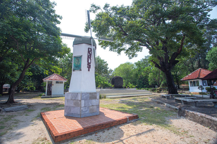
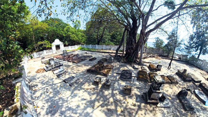
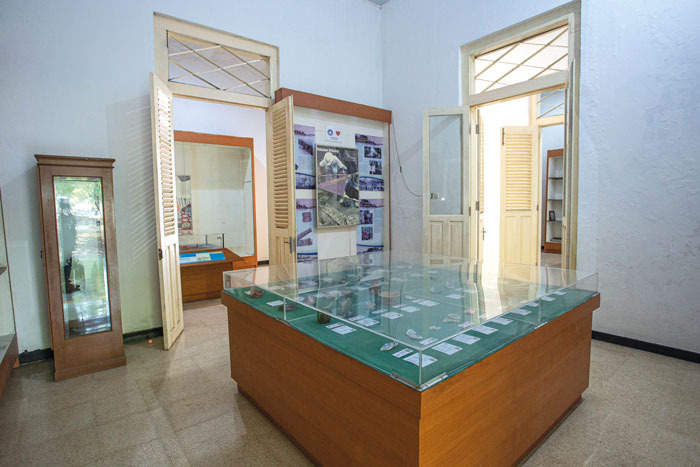
(위) Onrust 섬의 부두에 도착하는 방문객을 맞이하는 복제 풍차; (아래 왼쪽) Onrust 섬의 네덜란드 묘지. 여기서 훼손된 무덤은 열대병으로 고향에서 멀리 떨어져 사망한 식민 시대 거주자들의 삶과 죽음을 증언합니다; (아래 오른쪽) Onrust 고고학 박물관 내부의 분위기는 섬의 풍부한 과거를 보여줍니다. 역사 유물, 고고학적 발견, 수세기에 걸쳐 전략적인 해상 허브로서의 역할을 추적하는 전시가 있습니다. 사진: Des Syafrizal 제공)
17세기 중반부터 섬에는 창고, 직원 주택, 조선 시설이 건설되었습니다. 1656년 요새가 건설되었으며 경쟁 국가의 공격에 대응하여 반복적으로 확장되었습니다. 18세기에 Onrust는 병원, 교회, 주거 건물, 풍차를 포함한 광범위한 군사 및 민간 인프라를 갖추게 되었습니다.
유럽의 분쟁은 결국 자카르타 만으로 이어졌습니다. 영국군은 18세기 후반과 19세기 초에 섬의 일부를 공격하고 불태웠으며 1816년까지 그 지역을 점령했습니다. 네덜란드 통치가 회복된 후 Onrust는 해상 기능을 재개했습니다. 1911년에는 하지 순례자와 전염병에 걸린 환자들을 위한 검역소로 지정되었습니다.
과거 시설의 유적은 오늘날까지도 분명하게 보입니다. 절정기에 섬에는 각각 최대 100명의 하지 순례자를 수용할 수 있는 35개의 казарма가 있었습니다. 1933년 하지 검역 작업은 Tanjung Priok 항구로 이전되었습니다.
섬에는 여전히 네덜란드 묘지가 남아 있습니다. 약 52개의 무덤 중 대부분은 열대병으로 인해 어린 나이에 사망한 네덜란드 정착민과 관리에게 속합니다. 역사학자들은 Onrust는 살기에는 매우 건강하지 못했으며 질병이 끊임없이 위협을 가했다고 믿습니다.
섬과 그 주변 유적지에 대해 더 자세히 알아보려면 방문객들은 옛 병영과 병원의 폐허와 마주보는 과거 의사의 저택에 위치한 Onrust 고고학 박물관을 방문할 수 있습니다. 박물관은 정보 제공 디스플레이, Onrust 섬의 축소 모형, 그리고 식민지 시대와 해상 역사를 생생하게 보여주는 상호 작용 전시를 통해 섬의 역사에 대한 통찰력을 제공합니다.
박물관 소장품에는 Onrust와 인접한 섬에서 발견된 고고학 유물이 394점 포함되어 있습니다. 가장 눈에 띄는 것들 중에는 중국의 19세기 청나라 시대의 도자기 조각이 있으며, 이는 과거 바타비아를 더 넓은 아시아 지역과 연결했던 해상 무역 네트워크와 문화 교류에 대한 증거를 제공합니다.
방법:
카말 무아라 외에도 많은 여행객들이 저렴한 대중 보트 서비스로 유명한 무아라 앙케 부두에서 출발합니다. 마리나 안콜은 더 다양한 관광 페리와 개인 헌장을 제공합니다.
전통 보트 임대/스피드보트 임대: 보트당 약 350,000 인도네시아 루피아에서 1,000,000 인도네시아 루피아 (마리나 안콜 또는 무아라 카말과 같은 출발 부두와 보트 유형에 따라 다름).
지방 정부 관광선 (카팔 위사타 페다): 왕복 경로(무아라 앙케-치푸르-온루스트-켈로르) 티켓은 1인당 49,000 인도네시아 루피아입니다.
많은 여행사가 더 저렴한 가격으로 오픈 트립 패키지를 제공합니다. 세 개의 섬을 포함하는 오픈 트립은 1인당 120,000 인도네시아 루피아에서 175,000 인도네시아 루피아이며, 페리 타고, 입장권 및 안내원이 포함됩니다.
Benteng Martello, masih berdiri dengan gagah setelah berabad-abad, menyambut hangat pengunjung yang tiba di Pulau Kelor. Foto oleh Des Syafrizal.
Di luar pantai pasir putihnya, terumbu karang, dan resor tepi laut yang tenang, Kepulauan Seribu (Kepulauan Seribu) menawarkan pengalaman island hopping yang menarik yang sarat dengan warisan dan sejarah. Sejak abad ke-17 awal, mereka telah berfungsi sebagai zona penyangga dan pos terdepan untuk Perusahaan Hindia Timur Belanda (VOC) dan kemudian administrasi kolonial Belanda. Hari ini, sisa-sisa sejarah tersebar di seluruh pulau, memberikan pengunjung sekilas tentang masa lalu maritim Indonesia dan keindahan alam pulau lepas pantai Jakarta.
Kabupaten Kepulauan Seribu terletak di perairan Teluk Jakarta, dibatasi oleh dua tanjung: Tanjung Pasir di sebelah barat dan Tanjung Karawang di sebelah timur. Di ujung selatan kepulauan terdapat 10 pulau kecil, termasuk Rambut, Untung Jawa, Onrust, Kelor, Cipir, dan Bidadari. Dari era VOC hingga periode kolonial Belanda, pulau-pulau ini memainkan peran strategis dalam melindungi Batavia (Jakarta), sebagai benteng pertahanan, fasilitas karantina, gudang, dan pusat pengiriman.
Hari ini, banyak pulau telah diubah menjadi tujuan wisata. Ayer dan Bidadari telah menjadi tempat peristirahatan resor populer, sementara Untung Jawa tetap menjadi satu-satunya pulau yang dihuni secara permanen di gugusan selatan.
Seorang nelayan berlayar melintasi Teluk Jakarta, melewati rantai pulau bersejarah di sepanjang jalan. Foto oleh Des Syafrizal.
NOW! Jakarta bergabung dengan tim dari Unit Pengelola Museum Maritim Jakarta dalam kunjungan ke Kepulauan Seribu sebagai persiapan untuk peringatan 500 tahun Jakarta tahun depan. Perayaan akan berfokus pada pelestarian dan promosi warisan maritim kota, serta penciptaan program yang relevan. Berangkat dari Dermaga Kamal Muara di Jakarta Utara, kami menaiki kapal Museum Bahari ditemani oleh Mis’Ari, Kepala Unit Pengelola Museum Maritim. Kami menyeberangi Teluk Jakarta, menelusuri jejak sejarah berabad-abad saat kami menuju Kelor, Cipir, dan Pulau Onrust.
Pulau-pulau bersejarah ini adalah salah satu situs warisan yang dikelola oleh Unit Pengelola Museum Maritim, bersama dengan Museum Bahari, Menara Syahbandar, Jembatan Kota Intan, Rumah Si Pitung, dan Situs Sejarah Marunda.
Kami melewati pemukiman nelayan Kamal Muara dan Dadap, di mana kapal-kapal berwarna-warni berjajar di sepanjang dermaga. Dua puluh menit kemudian, kami tiba di tujuan pertama kami: Pulau Kelor.
(Di atas) Di dalam Benteng Martello, pengunjung dapat melihat benteng bersejarah yang masih kokoh berdiri meskipun termakan waktu; (Di bawah-Kiri) Sinar matahari menerangi benteng Martello yang terletak sekitar 9 meter di atas permukaan laut; (Di bawah-Kanan) Tangga di dalam benteng Martello berbentuk spiral bata, dirancang untuk menghubungkan lantai dasar ke platform atap. Pada masa militernya, atap berfungsi sebagai tempat meriam, memungkinkan para pembela memantau dan melindungi perairan sekitarnya. Foto oleh Des Syafrizal.
Pulau Kelor relatif kecil dan, karena erosi pantai selama berabad-abad, sekarang hanya mencakup 1,5 hektar. Pulau ini dikenal sebagai Kerkhof Eiland selama era kolonial Belanda, yang berarti “pulau kuburan”. Meskipun demikian, tidak ada bukti makam atau situs pemakaman yang pernah ditemukan di sana.
Pulau ini langsung dikenali dengan benteng Martello yang khas. Meskipun para sejarawan terus berdebat apakah itu terinspirasi secara langsung dari benteng Martello asli yang dikembangkan di sepanjang pantai Corsica, Prancis, struktur pertahanan serupa dapat ditemukan di tempat lain di Indonesia. Menara serupa juga dibangun di Pulau Onrust, Cipir, dan Bidadari, serta di Karang Trigoson dan Karang Mathilda, keduanya telah hilang ditelan laut. Mereka merupakan bagian dari jaringan pertahanan maritim yang lebih luas yang didirikan pada abad ke-19
Dibangun pada tahun 1850, benteng di Pulau Kelor adalah struktur berbentuk lingkaran dan silinder yang dibangun terutama dari bata merah. Berdiameter sekitar 14 meter, dindingnya setebal 2,6 m. Meskipun penampilannya yang tangguh, menara tersebut hanya berfungsi untuk tujuan defensif aslinya selama kurang dari 20 tahun. Pada tahun 1871, telah diubah menjadi gudang amunisi untuk armada Hindia Belanda.
Kepentingan militernya secara bertahap menurun, dan pada awal abad ke-20, sebagian besar telah terbengkalai. Sebuah artikel koran berjudul “Verlaten Eilanden” (Pulau Terbengkalai), yang diterbitkan pada tahun 1905, menggambarkan benteng tersebut sebagai terabaikan dan rusak. Sebagian besar kerusakan diperkirakan disebabkan oleh letusan dahsyat Krakatau pada tahun 1883, yang memicu tsunami dan gelombang kejut yang menghancurkan garis pantai di seluruh wilayah.
Setiap kapal yang memasuki teluk dari utara akan pertama kali menemui Kelor, menjadikannya sebagai garis pertahanan terdepan yang krusial.
Sebuah perahu mendekati dermaga, bersiap untuk sandar di Pulau Cipir. Foto oleh Des Syafrizal.
Dari Kelor, kami melanjutkan ke Pulau Cipir, yang juga dikenal sebagai Pulau Kahyangan (Belanda: Kuiper Eiland), yang muncul pada peta abad ke-18 dan ke-19 sebagai permukiman Eropa dan memainkan peran penting dalam operasi VOC.
Selama masa kejayaan perusahaan, Cipir berfungsi sebagai pusat penyimpanan dan logistik. Salah satu catatan paling jelas dari periode ini muncul dalam lukisan tahun 1769 oleh Johannes Rach, menggambarkan kapal dagang VOC Vreedenlust sedang diperbaiki. Adegan tersebut menggambarkan buruh budak menarik kapal tegak di bawah pengawasan seorang mandor yang membawa cambuk—pengingat pahit tentang biaya manusia di balik perdagangan kolonial.
Antara tahun 1850 dan 1853, benteng Martello dibangun di pulau tersebut. Namun, peran militernya terbukti singkat, dan struktur tersebut kemudian diubah menjadi gudang. Menjelang akhir abad ke-19, sebagian besar benteng dibongkar untuk memberi jalan bagi fasilitas yang melayani tujuan yang sama sekali berbeda: karantina.
(Kiri) Bangunan fasilitas karantina di Pulau Cipir; (Kanan) Sebuah meriam berdiri di antara reruntuhan rumah sakit dan pusat isolasi yang dulu ada di Pulau Cipir. Foto oleh Des Syafrizal.
Bersama dengan Pulau Onrust yang berdekatan, Cipir menjadi stasiun kesehatan masyarakat yang penting. Pembangunan fasilitas karantina dimulai pada tahun 1911, dan pada tahun berikutnya, mereka beroperasi. Pulau tersebut menampung para pelancong yang terkena penyakit menular dan kemudian erat kaitannya dengan perjalanan haji.
Seiring dengan meningkatnya fasilitas kesehatan di daratan, pentingnya pulau itu secara bertahap berkurang. Pada tahun 1958, kompleks karantina telah ditinggalkan dan akhirnya ditinggalkan. Banyak bangunan rumah sakit yang dulu dibongkar, dengan penduduk menyelamatkan batu bata dan kayu untuk digunakan di permukiman terdekat.
Tujuan akhir kami adalah Pulau Onrust, secara historis pulau tersibuk dan terpenting di Teluk Jakarta. Namanya berasal dari kata Belanda onrust, yang berarti “gelisah” atau “aktivitas tanpa henti”, mencerminkan peran lamanya sebagai pusat perdagangan maritim dan operasi angkatan laut.
Terletak secara strategis tepat di utara Batavia, Onrust menjadi salah satu pangkalan pulau terpenting VOC. Pergerakan kapal, barang, dan pekerja yang konstan mengubahnya menjadi pusat sibuk yang mendukung kapal yang melakukan perjalanan ke seluruh Asia dan Eropa.
Dalam bukunya Onrust dan Sekitarnya: Gugusan Pulau Bersejarah di Teluk Jakarta (Onrust and Surroundings: A Historic Island Cluster in Jakarta Bay), arkeolog Candrian Attahiyyat menjelaskan bahwa asal mula pemerintahan kolonial Belanda di Indonesia dapat ditelusuri langsung ke Pulau Onrust. Lokasinya yang strategis menjadikannya pangkalan ideal bagi VOC untuk membangun kendali atas Jayakarta (sebelum kota itu disebut Batavia).
(Di atas) Replika kincir angin menyambut pengunjung saat mereka tiba di dermaga di Pulau Onrust; (Di bawah-Kiri) Pemakaman Belanda di Pulau Onrust, di mana batu nisan yang lapuk menjadi saksi kehidupan dan kematian penduduk zaman kolonial, banyak di antaranya meninggal karena penyakit tropis jauh dari rumah; (Di bawah-Kanan) Suasana di dalam Museum Arkeologi Onrust menawarkan sekilas ke masa lalu pulau yang kaya, dengan artefak sejarah, temuan arkeologis, dan pameran yang melacak perannya sebagai pusat maritim strategis selama berabad-abad. Foto oleh Des Syafrizal).
Mulai pertengahan abad ke-17, gudang, rumah staf, dan fasilitas galangan kapal dibangun di pulau tersebut. Benteng menyusul pada tahun 1656 dan secara berulang kali diperluas sebagai tanggapan atas serangan dari kekuatan saingan. Pada abad ke-18, Onrust memiliki infrastruktur militer dan sipil yang luas, termasuk rumah sakit, gereja, bangunan perumahan, dan kincir angin.
Konflik Eropa akhirnya mencapai perairan Teluk Jakarta. Pasukan Inggris menyerang dan membakar sebagian pulau selama akhir abad ke-18 dan awal abad ke-19 sebelum menduduki wilayah tersebut hingga tahun 1816. Setelah pemulihan kendali Belanda, Onrust melanjutkan fungsinya sebagai pusat maritim. Pada tahun 1911, itu ditetapkan sebagai stasiun karantina untuk peziarah Haji dan pasien yang menderita penyakit menular.
Relik dari fasilitas lama masih terlihat jelas hingga saat ini. Di puncaknya, pulau tersebut menampung 35 barak, masing-masing mampu menampung hingga 100 peziarah Haji. Pada tahun 1933, operasi karantina Haji dipindahkan ke Pelabuhan Tanjung Priok.
Pemakaman Belanda masih ada di pulau tersebut. Dari sekitar 52 kuburan di sana, sebagian besar milik pemukim dan pejabat Belanda yang meninggal di usia muda, sering kali akibat penyakit tropis. Para sejarawan percaya bahwa Onrust jauh dari tempat yang sehat untuk ditinggali, dengan penyakit yang selalu menjadi ancaman.
Untuk mempelajari lebih lanjut tentang pulau dan situs warisan sekitarnya, pengunjung dapat menjelajahi Museum Arkeologi Onrust, yang terletak di bekas kediaman dokter di seberang reruntuhan barak dan rumah sakit lama. Museum ini menawarkan wawasan tentang sejarah pulau melalui pajangan informatif, model skala Pulau Onrust, dan pameran interaktif yang menghidupkan masa lalu kolonial dan maritimnya.
Koleksi museum mencakup 394 artefak arkeologi yang dipulihkan dari Onrust dan pulau-pulau tetangga. Di antara yang paling menonjol adalah pecahan keramik dan gerabah yang berasal dari Dinasti Qing abad ke-19 di Cina, memberikan bukti jaringan perdagangan maritim dan pertukaran budaya yang pernah menghubungkan Batavia dengan wilayah Asia yang lebih luas.
Cara Menuju Ke Sana:
Selain Kamal Muara, banyak wisatawan berangkat dari Dermaga Muara Angke, yang dikenal dengan layanan perahu umum yang terjangkau, sementara Marina Ancol menawarkan berbagai macam feri wisata dan sewa pribadi.
Sewa Perahu Tradisional/Sewa Speedboat: Sekitar IDR 350.000 hingga IDR 1.000.000 per perahu (tergantung dermaga asal seperti Marina Ancol atau Muara Kamal dan jenis perahu).
Perahu Wisata Pemerintah Daerah (Kapal Wisata Pemda): Tiket berharga IDR 49.000 per orang untuk rute pulang pergi (melintasi Muara Angke-Cipir-Onrust-Kelor).
Banyak operator wisata menawarkan paket perjalanan terbuka dengan harga yang lebih terjangkau. Paket Perjalanan Terbuka yang mencakup tiga pulau berkisar antara IDR 120.000 hingga IDR 175.000 per orang, dan termasuk perjalanan feri, tiket masuk, dan pemandu.
The Martello fortress, still standing proudly after centuries, warmly welcomes visitors arriving on Kelor Island. Photo by Des Syafrizal.
Beyond their white-sand beaches, coral reefs, and tranquil seaside resorts, Kepulauan Seribu (the Thousand Islands) offers fascinating island-hopping experiences steeped in heritage and history. Since the early 17th century, they have served as buffer zones and defensive outposts for the Dutch East India Company (VOC) and later, the Dutch colonial administration. Today, these historical remains are scattered across the islands, providing visitors with a glimpse into Indonesia’s maritime past and the natural beauty of Jakarta’s offshore islands.
The Thousand Islands Regency lies in the waters of Jakarta Bay, framed by two headlands: Tanjung Pasir to the west and Tanjung Karawang to the east. At the southern end of the archipelago are 10 small islands, including Rambut, Untung Jawa, Onrust, Kelor, Cipir, and Bidadari. From the VOC era through to the Dutch colonial period, these played a strategic role in protecting Batavia (Jakarta), as defensive fortresses, quarantine facilities, warehouses, and shipping hubs.
Today, many of the islands have been transformed into tourist destinations. Ayer and Bidadari have become popular resort retreats, while Untung Jawa remains the only permanently inhabited island in the southern cluster.
A fishermen sails across Jakarta Bay, passing a chain of historic islands along the way. Photo by Des Syafrizal.
NOW! Jakarta joined a team from the Jakarta Maritime Museum Management Unit on a visit to the Thousand Islands in preparation for Jakarta’s 500th anniversary next year. Celebrations will focus on preserving and promoting the city’s maritime heritage, as well as creating relevant programmes.Departing from Kamal Muara Jetty in North Jakarta, we boarded a Museum Bahari boat accompanied by Mis’Ari, the Head of the Maritime Museum Management Unit. We crossed Jakarta Bay, retracing centuries of history as we journeyed towards Kelor, Cipir, and Onrust islands.
These historic islands are among the heritage sites managed by the Maritime Museum Management Unit, alongside Museum Bahari, Menara Syahbandar, Jembatan Kota Intan, Rumah Si Pitung, and the Marunda Historical Site.
We passed the fishing settlements of Kamal Muara and Dadap, where colourful vessels lined the waterfront. Twenty minutes later, we arrived at our first destination: Kelor Island.
(Above) Inside the Martello Fortress, visitors can see the historic fort still standing strong despite the passage of time; (Below-Left) Sunlight streams into the Martello fortress which stands approximately 9 metres above sea level; (Below-Right) The staircases inside the Martello fortress are spiral brick structures, designed to connect the ground floor to the rooftop platform. In its military days, the roof served as a cannon emplacement, allowing defenders to monitor and protect the surrounding waters. Photos by Des Syafrizal.
Kelor Island is relatively small and, due to coastal erosion over the centuries, now spans just 1.5 hectares. It was known as Kerkhof Eiland during the Dutch colonial era, meaning “graveyard island”. Despite its name, however, no evidence of graves or burial sites has ever been discovered there.
The island is instantly recognisable by its distinctive Martello fortress. Although historians continue to debate whether it was directly inspired by the original Martello fortifications developed along the coast of Corsica, France, similar defensive structures can be found elsewhere in Indonesia. Similar towers were also built on Onrust, Cipir, and Bidadari Islands, as well as at Karang Trigoson and Karang Mathilda, both of which have since disappeared beneath the sea. They formed part of a wider maritime defence network established during the 19th century
Constructed in 1850, the fortress on Kelor Island is a circular, barrel-shaped structure built primarily from red brick. Measuring approximately 14 metres in diameter, its walls are an impressive 2.6 m thick. Despite its formidable appearance, the tower served its original defensive purpose for fewer than 20 years. By 1871, it had been converted into an ammunition store for the Dutch East Indies fleet.
Its military significance gradually declined, and by the early 20th century, it had largely fallen into disuse. A newspaper article titled “Verlaten Eilanden” (Abandoned Islands), published in 1905, described the fortification as neglected and deteriorating. Much of the damage is believed to have resulted from the catastrophic eruption of Krakatoa in 1883, which triggered a tsunami and shockwaves that devastated coastlines across the region.
Any vessel entering the bay from the north would first encounter Kelor, making it a crucial first line of defence.
A boat approaches the jetty, preparing to dock at Cipir Island. Photo by Des Syafrizal.
From Kelor, we continued to Cipir Island, also known as Kahyangan Island (Dutch: Kuiper Eiland), which appears on 18th- and 18th-century maps as a European settlement and played an important role in the VOC’s operations.
During the company’s heyday, Cipir served as a storage and logistics centre. One of the most vivid records of this period appears in a 1769 painting by Johannes Rach, depicting the VOC merchant vessel Vreedenlust undergoing repairs. The scene portrays enslaved labourers hauling the ship upright under the supervision of a foreman carrying a whip—a stark reminder of the human cost behind colonial trade.
Between 1850 and 1853, a Martello fortress was constructed on the island. However, its military role proved short-lived, and the structure was later converted into a warehouse. Towards the end of the 19th century, much of the fort was demolished to make way for facilities serving an entirely different purpose: quarantine.
(Left) Quarantine facilites buildings in Cipir island; (Right) A cannon stands amid the ruins of a former hospital and isolation acentre on Cipir Island. Photos by Des Syafrizal.
Along with neighbouring Onrust Island, Cipir became an important public health station. Construction of quarantine facilities began in 1911, and by the following year, they were operational. The island accommodated travellers affected by infectious diseases and later became closely associated with the Hajj pilgrimage.
As healthcare facilities on the mainland improved, the island’s importance gradually diminished. By 1958, the quarantine complex had fallen into disuse and was eventually abandoned. Many of the former hospital buildings were dismantled, with residents salvaging bricks and timber for use in nearby settlements.
Our final destination was Onrust Island, historically the busiest and most important of the islands in Jakarta Bay. Its name derives from the Dutch word onrust, meaning “restless” or “unceasing activity”, reflecting its long-standing role as a centre of maritime commerce and naval operations.
Strategically located just north of Batavia, Onrust became one of the VOC’s most important island bases. The constant movement of ships, goods, and workers transformed it into a bustling hub supporting vessels travelling throughout Asia and Europe.
In his book Onrust dan Sekitarnya: Gugusan Pulau Bersejarah di Teluk Jakarta (Onrust and Surroundings: A Historic Island Cluster in Jakarta Bay), archaeologist Candrian Attahiyyat explains that the origins of Dutch colonial rule in Indonesia can be traced directly to Onrust Island. Its strategic location made it an ideal base from which the VOC could establish control over Jayakarta (before the city was called Batavia).
(Above) Replica windmills greet visitors as they arrive at the pier on Onrust Island; (Below-Left) A Dutch cemetery on Onrust Island, where weathered gravestones bear witness to the lives and deaths of colonial-era residents, many of whom succumbed to tropical diseases far from home; (Below-Right) The atmosphere inside the Onrust Archaeological Museum offers a glimpse into the island’s rich past, with historical artefacts, archaeological finds, and exhibits that trace its role as a strategic maritime hub through the centuries. Photos by Des Syafrizal).
Beginning in the mid-17th century, warehouses, staff housing, and shipyard facilities were constructed on the island. A fort followed in 1656 and was repeatedly expanded in response to attacks from rival powers. By the 18th century, Onrust featured extensive military and civilian infrastructure, including hospitals, churches, residential buildings, and a windmill.
European conflicts eventually reached the waters of Jakarta Bay. British forces attacked and burned parts of the island during the late 18th and early 19th centuries before occupying the area until 1816. Following the restoration of Dutch control, Onrust resumed its maritime functions. In 1911, it was designated as a quarantine station for Hajj pilgrims and patients suffering from infectious diseases.
The ruins of the former facility remain clearly visible today. At its peak, the island housed 35 barracks, each capable of accommodating up to 100 Hajj pilgrims. In 1933, Hajj quarantine operations were relocated to Tanjung Priok Port.
A Dutch cemetery remains on the island. Of the approximately 52 graves there, most belong to Dutch settlers and officials who died at a young age, often as a result of tropical diseases. Historians believe that Onrust was far from a healthy place to live, with disease posing a constant threat.
To learn more about the island and its surrounding heritage sites, visitors can explore the Onrust Archaeological Museum, housed in a former doctor’s residence opposite the ruins of the old barracks and hospital. The museum offers insights into the island’s history through informative displays, a scale model of Onrust Island, and interactive exhibits that bring its colonial and maritime past to life.
The museum’s collection includes 394 archaeological artefacts recovered from Onrust and the neighbouring islands. Among the most notable are ceramics and pottery fragments dating from China’s 19th-century Qing Dynasty, providing evidence of the maritime trade networks and cultural exchanges that once linked Batavia with the wider Asian region.
Getting there:
Besides Kamal Muara, many travellers depart from Muara Angke pier, known for its affordable public boat services, while Marina Ancol offers a wider range of tourist ferries and private charters.
Traditional boat rental/speedboat rental: Around IDR 350,000 to IDR 1,000,000 per boat (depending on the pier of origin such as Marina Ancol or Muara Kamal and the type of boat).
Local Government Tourist Boat (Kapal Wisata Pemda): Tickets cost IDR 49,000 per person for the round-trip route (crossing Muara Angke-Cipir-Onrust-Kelor).
Many tour operators offer open trip packages at more affordable prices. An Open Trip covering three islands ranges from IDR 120,000 to IDR 175,000 per person, and includes the ferry ride, entrance ticket, and guide.